 Hardanger Shop
Mountains
Hardangervidda: Trolltunga is outside the national park
Hardangervidda is two sizes under one name: a plateau of about 8,000 square kilometres and a national park of 3,422. More than half the park is in Hardanger, yet Trolltunga and Vøringsfossen, where most visitors from Odda stand, are outside it.
Send it on hardanger.shop/guide/en/hardangervidda
You stood on the plateau, not in the national park.
- The plateauc. 8,000 km²Seven municipalities in three counties. Store norske leksikon.
- The national park3,422 km²1,813 of them in Hardanger municipalities. The 1981 regulation.
- Trolltunga and VøringsfossenOutside the parkOn the Norwegian Environment Agency's map. Our query, 13 November 2026.
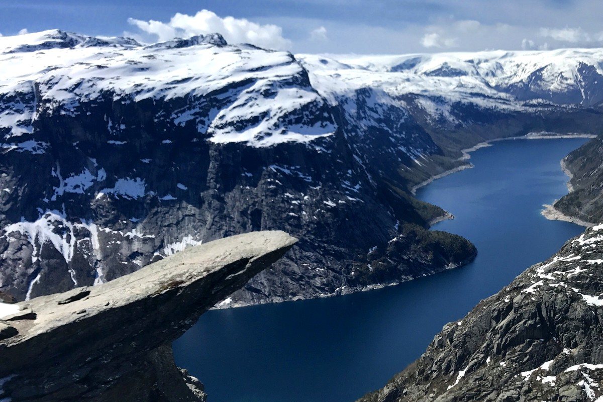
Where you stood
Out on Trolltunga you are about 1,180 metres above the sea, east of Tyssedal, and the view runs "mot Hardangervidda", towards the plateau, in the words of Store norske leksikon, the Norwegian encyclopaedia. It is easy to think you are standing in Hardangervidda National Park.
You are not.
The Norwegian Environment Agency, Miljødirektoratet, keeps a map of every protected area in Norway, and the map can be queried point by point. We entered the point Kartverket, the mapping authority, uses for Trolltunga in its place-name register: 60.13318 north, 6.75472 east. The answer was empty. No national park, and no protected area of any kind. The same for Vøringsfossen, at the GPS point the National Tourist Routes print for the stop: 60.42669 north, 7.251631 east. As a control we asked about Hårteigen, the mountain in the middle of the plateau. The park came back at once.
How far the rock is from the boundary, we have not measured. What we know is that the points are outside.
But they are on the plateau. Store norske leksikon draws Hardangervidda "i vid forstand", in the wide sense, with Sørfjorden and the Odda valley on the west and Eidfjorden and Simadalen on the north-west. Trolltunga is east of Sørfjorden. Vøringsfossen falls in the Bjoreio river, which the encyclopaedia counts among the rivers that come off the plateau. As we read that line, at both places you are on the plateau's edge. You stood on the plateau, not in the national park.
One name, two sizes
Hardangervidda "er på rundt 8000 kvadratkilometer", about 8,000 square kilometres, says Store norske leksikon. It lies "stort sett i en høyde av 1100–1400 meter over havet, høyest i vest", mostly at 1,100 to 1,400 metres and highest in the west, and it takes in parts of seven municipalities: Tinn and Vinje in Telemark, Nore og Uvdal and Hol in Buskerud, and Ulvik, Eidfjord and Ullensvang in Vestland.
The national park is smaller. It was created on 1 June 1981, and the protection regulation on Lovdata says that "det samla areal i nasjonalparken er omlag 3422 km²", that the park as a whole is about 3,422 square kilometres. That is less than half the plateau. The Norwegian Trekking Association says the same in words on ut.no: "Omtrent halve viddeplatået er vernet som nasjonalpark", roughly half the plateau is protected as a national park.
English Wikipedia gives about 6,500 square kilometres for the plateau. On that figure the park is a little over half. We go with the encyclopaedia, but the pages do not agree, and neither says where its number comes from.
Ulvik is the difference between the two lists of municipalities. It is on the plateau, but the park "berører alle kommunene på Hardangervidda med unntak av Ulvik", touches every municipality on the plateau except Ulvik, says SNL. The Environment Agency's map lists six park municipalities, and Ulvik is not one of them.
More than half the park is Hardanger
The regulation divides the park among the old counties: "Av dette ligg ca. 1813 km² i Hordaland fylke, 767 km² i Telemark fylke og 842 km² i Buskerud fylke." About 1,813 square kilometres in Hordaland, 767 in Telemark, 842 in Buskerud. The Hordaland municipalities it names are Odda, Ullensvang and Eidfjord. All three are Hardanger, and Odda has been part of Ullensvang since 2020. 1,813 of 3,422 is about 53 percent. That calculation is ours.
In Eidfjord the park is a large part of the municipality itself. "Hardangervidda nasjonalpark utgjer om lag 38 prosent (575 km²) av arealet i kommunen", about 38 percent of Eidfjord's area, says SNL on Eidfjord. Hardangervidda Natursenter, one of the park's two visitor centres, is in Eidfjord and opened in 1995. The other is at Skinnarbu in Telemark.
The park's highest point is in Hardanger too. It is Sandfloegga, 1,721 metres, which SNL calls the highest mountain in Ullensvang. The point Kartverket uses for the summit is inside the park on the map. When SNL's article on Hardanger lists the highest mountains in Hardanger, three plateau names are on it: Hardangerjøkulen, Hårteigen "sentralt på Hardangervidda", in the middle of the plateau, and Sandfloegga.
How much of the plateau itself is Hardanger, we have found nobody who has worked out. So we print no number for it.
"Largest" depends on the page
The plateau and the park both get the word "largest", but not for the same area:
| Source | What | Largest in |
|---|---|---|
| SNL, Hardangervidda | High mountain plateau | Norway and Europe |
| English Wikipedia | Plateau "of its kind" | Europe |
| Environment Agency, brochure | Highland plateau | Northern Europe |
| DNT, ut.no | High mountain plain | Northern Europe |
| Environment Agency, brochure | National park | Norway |
| SNL, the national park | National park | Mainland Norway |
Europe or Northern Europe is not a small difference. None of the pages says which plateaus it compared.
For the park it is simpler. SNL calls it "arealmessig den største nasjonalparken i Fastlands-Norge", the largest by area in mainland Norway, and the table of Norwegian national parks in the same encyclopaedia shows why it says mainland: Sør-Spitsbergen National Park on Svalbard has 5,025 square kilometres of land. The Environment Agency's brochure says "The largest National Park in Norway" without that qualifier.
The reindeer are a hunting figure
Many pages say the plateau has Europe's largest wild reindeer herd. The number of animals changes, and the figures we found carry no date. SNL gives "om lag 10 000 dyr", about 10,000 animals, in its plateau article and "omkring 6000 vinterbeitende dyr", about 6,000 wintering animals, in its park article. The Norwegian government wrote in 2021 that about a third of Norway's wild reindeer live here.
What has a date is the hunt. Statistics Norway says Hardangervidda is the largest wild reindeer area, and that 513 animals were shot in 2025, against a quota of 3,000. Most were older bucks, on purpose. Chronic wasting disease has been found twice on the plateau, first in September 2020, says the Norwegian Wild Reindeer Centre. Shooting older bucks is meant to make it less likely the infection spreads.
We have not seen reindeer on the plateau, and we have not crossed it. Whether the road over is open today is on the Norwegian Public Roads Administration's pages, and what the winter roads cost you is in Hardanger in winter. How long the day at Trolltunga takes is in How long does Trolltunga take?.
From the shop
The photograph at the top comes as a poster, a mug and a sticker. It shows the edge of the plateau, not the national park.


We have no physical shop in Odda. What you order is printed to order and sent by post.
Sources
Checked 13 November 2026:
- Hardangervidda, Store norske leksikon, Geir Thorsnæs, updated 28 April 2026. About 8,000 km², seven municipalities, 1,100–1,400 metres, the boundary "i vid forstand", about 10,000 animals, the park and Ulvik.
- Hardangervidda nasjonalpark, SNL, Leif Ryvarden and Knut Are Tvedt, updated 4 July 2025. 1 June 1981, 3,422 km², Sandfloegga, mainland Norway, about 6,000 animals, two visitor centres.
- Hardanger, SNL, updated 24 February 2025, Eidfjord, SNL, updated 22 May 2026, Trolltunga, SNL, updated 26 January 2023, Sandfloegga, SNL, and Nasjonalparker i Norge, SNL.
- Forskrift om vern for Hardangervidda nasjonalpark, FOR-1981-04-10-4830, Lovdata, last amended 2013. 3,422 km², 1,813 in Hordaland, 767 in Telemark, 842 in Buskerud.
- Protected areas map service, Miljødirektoratet, point queries 13 November 2026. The points for Trolltunga (Kartverket, place number 429403), Vøringsfossen (National Tourist Routes) and Sandfloegga (Kartverket, place number 247761), with Hårteigen as the control.
- Hardangervidda National Park, Miljødirektoratet brochure, undated.
- Hardangervidda nasjonalpark, DNT on ut.no, undated.
- Fortsatt lave fellingstall for villrein, Statistics Norway, 12 December 2025. Nytt tilfelle av skrantesjuke på Hardangervidda, Norsk villreinsenter, 9 October 2022. Tilrår ikkje ekstraordinære uttak av villrein på Hardangervidda, regjeringen.no, 23 November 2021.
- Hardangervidda, English Wikipedia, edited 15 April 2026, read as a lead, not a source.
- The 53 percent is ours, from the regulation's figures. The photograph at the top is ours, taken on 15 May 2017, the same one as in the Trolltunga piece.